
(grazie a http://mitzafanebas.invictisvictivicturi.org e http://www.sardegnaambiente.it)
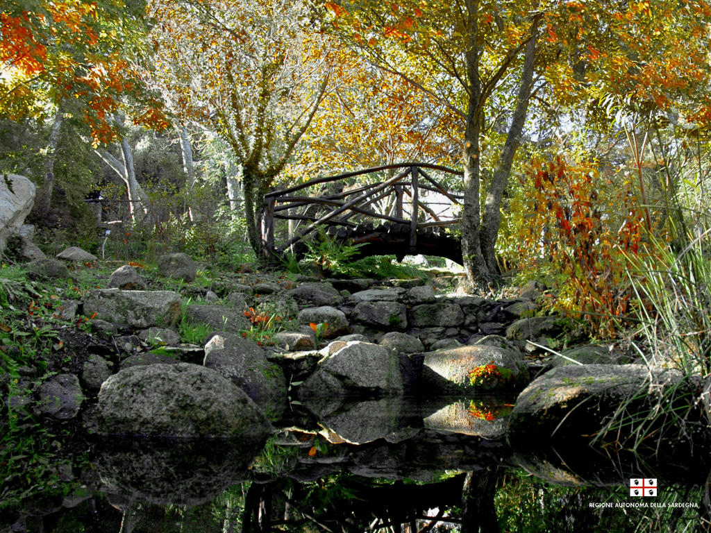
LA FORESTA DEL MARGANAI
Un territorio suggestivo, fatto di cascate, boschi fittissimi, cervi, miniere e villaggi abbandonati, sentieri di trekking magnifici, grotte, canyon rocciosi, fonti ovunque, vegetazione colorata...
Si estende nei seguenti comuni: Iglesias, Domusnovas, Fluminimaggiore
Superficie: 3650 ettari
Descrizione generale
Acquistata nel 1979, la Foresta Demaniale di Marganai ha conservato caratteristiche molto suggestive - nonostante il paesaggio naturale sia stato oggetto di interventi anche molto pesanti come le aree che sono state in passato oggetto di intenso sfruttamento minerario e che nonostante tutto, hanno conservato la loro bellezza paesaggistica.
Marganai The forest falls within part of the project "Natural Park of Monte Linas, Marganai-Oridda, Montimannu" regarded as scenic areas under the Legislative Decree 490/1999 (formerly L 1497/39), Art. 139 and 146. North Marganai compendium of about 450 ha, is included in the Site of Community Importance (SCI) Monte Linas under Presidential Decree No. 357, 08/09/1997 transposing the Habitats Directive 92/43/EEC "on the conservation of natural habitats, flora and fauna, for the preservation of biodiversity. Within the forest, always in accordance with LR 31/89 is identified as an area of \u200b\u200bgreat naturalistic interest the area of \u200b\u200bthe Cave of St. John, a majestic monument that is one of the largest cavity sardines. A real cave-tunnel traversed by a road that runs parallel to the Rio Sa Duchessa under a high limestone cliff where numerous archaeological remains are found, likely remnants of cyclopean walls.
(In the Forest of Marganai also home to the helicopter base of the same name which has a logistical role important in the context of the Regional Plan for the Defence of summer fires.)
The forest is an important destination for tourists and scholars, and You can visit following numerous paths and trails, many of which are extremely suggestive. And 'this a guesthouse, is currently not operational.
tours are possible even at the botanical garden, made for scientific-educational, which is represented the immense wealth of flora in this area is rich . Marganai is in fact a laboratory study and monitoring of forest ecosystems Mediterranean.
held here for ten years continuously extensive investigations on the vegetation, the condition of the hair, the chemical content of leaves and soil, changes in the growth of trees, atmospheric deposition, climate and microclimate, ozone and biodiversity. Data vengono elaborati da 9 Centri di ricerca di rilevanza nazionale (Centri di ricerca del C.F.S., C.R.A. del Mi.P.A.F, CNR, Università). I principali risultati ed ulteriori informazioni sul progetto sono peraltro disponibili sul sito del Corpo Forestale.
Descrizione geologica
I substrati litologici sui quali insiste l’area della foresta sono costituiti da calcari, dolomie e calcari dolomitici del Paleozoico Mesozoico. Dal disfacimento di queste rocce carbonatiche si ha la formazione di suoli da profondi a poco profondi, a tessitura franco-sabbioso-argillosa ad argillosa, da mediamente a poco permeabili, a reazione neutra e buon contenuto di sostanza organica, caratterizzati a volte dalla presenza di rocciosità e stoniness substantial, partly because of their high erodibility feature.
From the geomorphological point of view is represented by a massive forest that are followed with rugged peaks and troubled, especially in the northern area is very hilly with broad expanses of rock outcrops.
The rivers are mostly seasonal flow, the main ones are Sarmentus Riu, Riu Sa Duchessa, Riu Oridda. The catchment area is that of Flumini Mannu. The altitude varies from 214 m to 1009 m asl (Monte Nipis).
Vegetation
The territory in question is part of the climax forest of oak and suffers from excessive human pressure is with repeated fires with pasture. These events have helped to create secondary scrub formations, cisteti and scrubland. Attempts have been numerous reforestation using species of the genus Pinus. The few patches of holm oak in the area are attributable to the association of Viburnum-Quecetum ilicis: This training mesic with sporadic presence of arbutus and massive entrance of sclerophyllous termoxerofile lower horizon. Very large artificial afforestation are made from 1914 mainly with conifers (pine, Aleppo pine and radiata pine), have recently been used also deciduous trees (oak, cork and oak). The undergrowth is almost sempre formato da elementi della macchia a oleastro (Olea europaea var. sylvestris) e lentischio.
Nella foresta di Marganai la funzione protettiva è svolta in modo piuttosto efficiente dalle formazioni boschive naturali presenti. Mentre in quelle aree ricostituite con rimboschimenti, non ancora affermati, tale funzione non è garantita a pieno per via dello scarso grado di copertura vegetale. Al fenomeno degli incendi è dovuto, l’insediamento di formazioni a macchia secondaria, di cisteti e garighe, che si affermano soprattutto in aree con suoli poco profondi ed esposte ai venti dominanti. Queste ultime formazioni, per la modesta copertura vegetale, per il ridotto apparato radicale e della scarsa lettiera prodotta, esplicano una scarsa intercettazione rainfall and hence low regimante action.
In the north east of the forest, plain Oridda, was the subject of experimentation in the area of \u200b\u200bplantations for wood production and carried out by the group deleted SAFSpA National Agency for the pulp and paper (ENCC). The forest of
Marganai is full of many wildlife species such as the boar (Sus scrofa), wild cat, peregrine falcon (Falco peregrinus) and so on. Some areas may be considered suitable for the reintroduction of the Corsican red deer (Cervus elaphus corsicanus) and mouflon (Ovis ammon musimon). The presence of different animal species, has meant that this forest has a highly valued natural environment. Furthermore the area of \u200b\u200bforest Marganai is also patronized by the royal eagle.
The flora is both rich in species, with a significant number of endemic flora, which has been preserved for geological clear distinction with the surrounding territories. To get
reach and enter Iglesias: arriving from Cagliari SS 130 or it's go on until the 50 km.
move then toward the city center, walking, in order: Church Avenue mansion, via Cappuccini Via Valverde and reaching the central square Sella.
From here, you can easily find directions to Fluminimaggiore they place, long way away and Eleonora Fontana, SS 126.
along the highway up to exceed the 43 km of the same, then take the SP 89 to the junction for the village of San Benedetto.
After about 2.5 km on the SP 89 will reach the small town: here is on the right road at the intersection of Linas (aka SP 89) and points via S. Michele, the words "Park Marganai" to reach the State Forest, which is 2.8 km (access from the resort Mamenga).
GPS coordinates input forest (location Mamenga): N 39 ° 21 '26 "E 008 ° 33' 45.6" (DMS coordinates, WGS84 reference system).
Tour
The path of "Case Marganai"
- (thanks to www.vibraf.it9)
From: Grotta di San Giovanni (192)
To: Punta San Michele (906) Case Marganai (734 )
A: Malacalzetta
Length: 12 km
Time: 4:30 am
Signs: red diamonds with white stripe
starting point. The South entrance of the Cave of St. John can be reached from Cagliari to the SS 130 "Iglesiente" From this we bring to Domusnovas. From the village, a short stock asphalt road leads to the cave, which is crossed the road from side to side.
intermediate points. The Case Marganai are accessible through a road that branches off from the village of San Benedetto, in turn, reached with a short course by Iglesias. The stock, after 3 km, is barred to motorized traffic and after a further 3 km to reach homes Marganai. Mine Reigraxius is also accessible from the valley of the Rio Sarmentus, paved road through the Cave of St. John and turning right at the first fork 750 m. after leaving the cave, to take stock, on a natural background which is the initial part of another marked route (see route "Gutturu Farris, square orange signs).
point of arrival. The abandoned mining town of Malacalzetta stock is just down the street from San Benedetto (3.5 km from this).
Description of the route. From with latch South Cave near San Giovanni (on the left of the opening of the cave, for those coming from Domusnovas), branches off a paved road that leads, in 150 m., the country church of San Giovanni. From here, continue westwards before, in the direction of the channel on s'Ega Boi, then, with sudden detour to NN0, goes to the low saddle between Mount Water (540), crossed by the Grotta di San Giovanni, and the Punta Corru at (528), which are noted the steep limestone walls. Once at the saddle (at 0.10), leave la direzione originaria (andando dritti si discenderebbe all'ingresso N della Grotta di San Giovanni) e si va verso Ovest, a tornanti lungo un ripido pendio che si dirige alla base della parete calcarea di Punta su Corru. In corrispondenza di un roccione panoramico, cessa la salita e si prosegue quasi in piano fino a dei ruderi adiacenti ad una galleria, presso una fascia frangifuoco (ore 0.30-0.40).
Da qui, il panorama si estende alle sottostanti valli del Rio Sarmentus e del Rio di Monte Narba. La mulattiera inizia a scendere di quota approssimandosi al vallone del Rio Corovau. Prima di raggiungere questo, muta direzione, immettendosi verso destra in una sterrata forestale ex-mineraria che proviene dal fondovalle. Dopo un breve tratto in discesa, turns sharply left uphill (0.20-1 hours). Going downhill, the short "path Corovau" with the path that really goes on a section of ex-mining stock, marked by signs and yellow squares, bring back the valley of the Rio Sarmentus, upstream of the Cave of St. John.
The track climbs to thick curves to its confluence with the stock that comes from forest homes Marganai (hours 1-2). Turn left onto the main road would be reached soon at the San Michele (906), occupied the lookout tower on fire and radio / TV and telephone.
signs instead continue to the left, about 1 km on the stock, and then back in the woods on the left side of the road on a gravel forest in slightly uphill (hours 0:15 to 2:15). This should be perpendicular to cross the main road of "Sa Martinedda" starts to go down significantly by a canal and through another forest road, which brings about the Old Cantoniera Marganai (hours 0:30 to 2:45). Turn right on this, after 150 m. signs show a fall in the woods uphill and lead to the Houses Marganai (0.15-3 hours).
path down the avenue of lime trees flanking II wall, you reach a large clearing. The route continues on the opposite side of this. Just beyond, the route passes over an old trail, very scenic, which bends with dense, it follows Reigraxius to mine, situated in a picturesque location within a mountain ridge forest density (hours 0:45 to 3:45). In the lower part of the vast area occupied by the mine dumps, the route goes to identify with the channel Gutturu Farris, following upstream.
From the valley, the trail comes instead of Gutturu Farris, square signs with orange, which comes from the valley of the Rio Sarmentus. Along the Gutturu Farris, following signs red and white, you go to reach Malacalzetta (hours 0:45 to 4:30).
warnings. The difference is the commitment to cover the medium high (above 1000 m). The presence of excavations, tunnels and several landslides along the way, while visible light daytime, extreme caution if you carry with you 'and not recommended for minors in any way, this itinerary with subdued light.
travel schedules are reported, where necessary, in two ways, indicating that the last segment of part-time and total route described to the point indicated. Id, 1:30 to 2:30 hours means: part-time from the last point described; 1:30 am: Total time from start of the trip: 2:30 am.
0 comments:
Post a Comment